
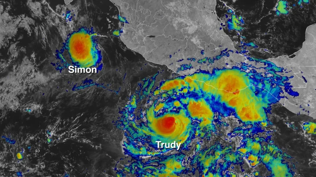
The storm is intensifying as it approaches the Mexican Pacific coast between Manzanillo and Cabo Corrientes — a stretch that includes resort towns, fishing communities, and port infrastructure. Residents are being told to move now.
BREAKING · WEATHER · MEXICO · PACIFIC
MEXICO CITY — Hurricane Trudy was strengthening Friday as it bore down on the Mexican Pacific coast, prompting authorities to issue a hurricane warning for a roughly 200-mile stretch of coastline from Manzanillo north to Cabo Corrientes. The National Hurricane Center and Mexican meteorological authorities reported the storm was intensifying and could make landfall within 24 to 36 hours. Communities along the affected coast were ordered to prepare for storm surge, destructive winds, and heavy rainfall.
The warning zone includes the port city of Manzanillo — one of Mexico’s largest Pacific cargo ports — as well as smaller fishing villages and the resort corridor north of it. Emergency management agencies in Jalisco and Colima states activated their highest alert levels and began organizing evacuation assistance for residents in low-lying coastal areas.
The Storm Track and What It Means
Trudy had been tracking northeast across the eastern Pacific, a path that gave it time over warm ocean water to intensify before landfall. The National Hurricane Center projected landfall near or just south of Cabo Corrientes, a prominent headland that juts into the Pacific south of Puerto Vallarta. The geography concentrates storm surge risk on the northern side of the cape, where several communities sit at low elevation.
Puerto Vallarta itself, one of Mexico’s largest beach resort destinations, was on the edge of the warning zone and the track closely. Hotel operators were securing outdoor furniture and warning guests. Flights at Gustavo Diaz Ordaz International Airport were already being affected by cancellations and rerouting.
“The coast between Manzanillo and Cabo Corrientes has not seen a storm at this intensity in several years. Residents need to take this seriously.” — Mexican civil protection official, speaking to AP
Port and Economic Exposure
Manzanillo handles a significant share of Mexico Pacific cargo traffic, including containerized imports and vehicle shipments. A direct hit or even a near-miss at hurricane strength would close the port for days, with downstream effects on supply chains across the country. The port was already reducing operations Friday afternoon as the storm approached, and the Mexican navy repositioned vessels to protected anchorage.
WHAT HAPPENS NEXT
► Landfall expected within 24-36 hours; exact track will determine which communities take the worst impact.
► Evacuation orders are being enforced in the most exposed coastal communities.
► Manzanillo port suspended operations Friday afternoon; resumption depends on storm passage.
► Puerto Vallarta airport issuing advisories; airlines canceling and rerouting flights.
► Mexican military and federal emergency services pre-positioned for immediate post-storm response.
| CONFIDENCE: HIGH | Storm confirmed by AP and National Hurricane Center. Warning zone from Manzanillo to Cabo Corrientes verified against NHC official advisory. Port closure and evacuation orders from Mexican civil protection agency confirmed. |
| Bias Check | ||
| Left-Lean | Center | Right-Lean |
| Notes climate change as a factor in Pacific hurricane intensification patterns. | Reports the storm track, the warning zone, and the evacuation context as confirmed. | Standard weather coverage; limited ideological dimension. |
| Assessment | ONYX presents confirmed NHC and AP data. Climate context noted as scientific consensus without political framing. | |
SOURCES
► Associated Press — Hurricane Trudy track, warning zone, and evacuation orders
► National Hurricane Center — Official advisory and landfall projection