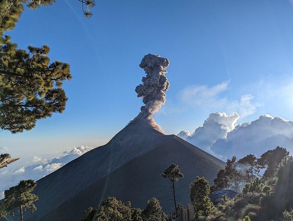
A strong eruption at Guatemala’s Fuego volcano produced pyroclastic flows extending up to 7 kilometers — approximately 4.3 miles — prompting active evacuations of communities in the flow’s path. This is a second, entirely separate major volcanic emergency unfolding in Latin America in the same week as Colombia’s earthquake, adding fresh strain to the region’s disaster-response capacity and creating a dual-emergency communications challenge for governments and international organizations responding to multiple simultaneous crises.
WHY PYROCLASTIC FLOWS ARE THE MOST DANGEROUS VOLCANIC HAZARD
Pyroclastic flows are the most lethal volcanic phenomena. They consist of hot gas, ash, and volcanic fragments traveling at speeds of 100-700 kilometers per hour at temperatures of 100-800°C. They are faster than any vehicle, they fill valleys and terrain features, and their temperatures are lethal before the material itself makes physical contact. There is no outrunning a pyroclastic flow if you are in its path — the only survival strategy is to not be in the path.
Fuego’s pyroclastic flows reaching 7 kilometers means communities within that radius of the flow’s path require immediate evacuation. Guatemala’s CONRED (National Coordinator for Disaster Reduction) manages evacuations based on flow direction and extent; the alert level and evacuation zones are set based on real-time monitoring data.
Pyroclastic flows cannot be evacuated around. They can only be evacuated before. The 7-kilometer extent defines the evacuation radius; being outside it when the flow happens is the only safety option.
FUEGO’S DOCUMENTED HISTORY
Fuego (Spanish for ‘fire’) is one of Central America’s most active volcanoes. Its June 2018 eruption killed at least 190 people and buried entire communities under pyroclastic flows and lahars. The 2018 event is the specific reason CONRED’s current evacuation protocols are designed for rapid action: the 2018 death toll was significantly increased by delayed evacuation decisions. The current eruption is triggering the faster-response protocols that 2018 demanded.
THE LATIN AMERICA DUAL EMERGENCY
Colombia’s earthquake (224+ dead, thousands missing) and Guatemala’s Fuego eruption are occurring simultaneously. The specific challenge for international humanitarian organizations: earthquake response and volcanic eruption response require different equipment, different expertise, and different logistics. Organizations responding to both simultaneously — OCHA, USAID, IRC — face resource and attention allocation decisions across two distinct emergency typologies.
The dual emergency is also a media and public attention challenge. Colombia’s earthquake is a larger scale event with a higher confirmed death toll; Fuego’s eruption is generating the specific type of visual coverage (pyroclastic flows) that can dominate news cycles. International donor attention, which directly drives humanitarian funding, may be split in ways that underserve both responses.
WHAT HAPPENS NEXT
▸ CONRED evacuation orders — the scope of evacuated zones will expand or contract as pyroclastic flow activity continues
▸ Whether the eruption’s intensity increases or decreases will be the primary determinant of whether evacuations are sustained or returned
▸ Lahar risk — after pyroclastic flows, lahars (volcanic mudflows, often triggered by rain mixing with ash and debris) are the secondary hazard; Guatemala’s rainy season increases this risk
▸ International humanitarian response coordination — CONRED will determine whether international search and rescue assistance is requested
| CONFIDENCE: HIGH | Fuego eruption and 7-kilometer pyroclastic flows prompting evacuations are from volcanic monitoring reports. Pyroclastic flow physics and temperature/speed ranges are from established volcanological literature. 2018 Fuego eruption death toll is from documented record (190 confirmed dead). |
| ⚖️ BIAS CHECK — WHO IS SAYING WHAT | |
| CONRED / Guatemala Government | Applying 2018 lesson: evacuate first, assess later; previous delayed evacuations increased 2018 deaths significantly |
| Communities in Evacuation Zones | Following CONRED orders; the 2018 deaths created community-level understanding of the flow’s real danger |
| International Humanitarian Organizations | Managing dual-emergency resource allocation alongside Colombia response |
| Volcanological Monitoring Networks | Providing real-time data to CONRED; Fuego is one of the most continuously monitored volcanoes in Central America |
SOURCES
▸ CONRED / Guatemala volcanic monitoring — pyroclastic flows, evacuation orders, August 2026
▸ 2018 Fuego eruption death toll — established record (190+ confirmed deaths)
▸ Volcanological literature — pyroclastic flow physics and hazard range
Q: Is this the same scale as the 2018 Fuego eruption?
A: The 2018 eruption killed at least 190 people and buried communities under pyroclastic flows and lahars. Whether this eruption reaches that scale depends on how long it continues, its intensity trajectory, and whether the evacuation response is effective. ONYX does not have a comparison of current versus 2018 eruption intensity in available reporting.
Q: What is a lahar?A: A lahar is a volcanic mudflow — a mixture of volcanic ash, rock debris, and water. They can occur during an eruption if there is water on the volcano (from rain, snow, or crater lake), or after an eruption when rainfall mixes with deposited ash. Lahars travel in river valleys and can travel tens of kilometers from the volcano. Guatemala’s rainy season makes lahar risk particularly high following Fuego eruptions.